
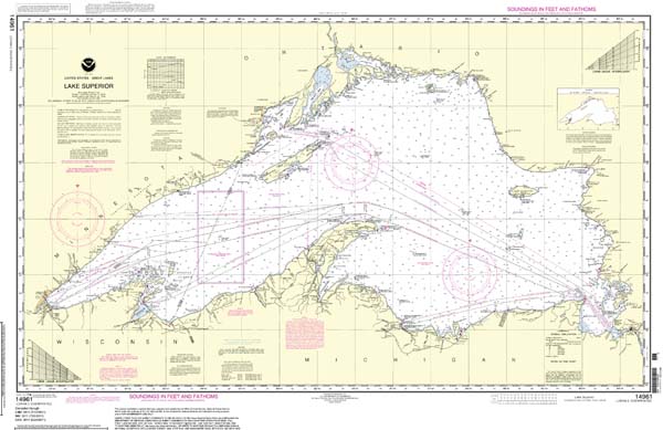
Lake Superior, the greatest of the Great Lakes, is deserving of its superlative moniker, for it’s “superior” on several fronts. It’s by far the largest of the four bodies that outline Michigan (plus Lake Ontario); the deepest (more than 1,300 feet at its nadir); the coldest (an average temperature of 40 degrees Fahrenheit in the summer); and is, in surface area, the largest freshwater body in the world. Sailors use nautical charts, such as the one above of Lake Superior (30 inches high, 45 inches wide), for navigation purposes, but like old-school roll-down maps in geography class, they also make interesting — and educational — wall art.
The Ojibwe (or Chippewas) called Lake Superior “Kitchi-Gummi,” or great water, and Longfellow immortalized it as “Gitchee Gumee” in the poem The Song of Hiawatha, as did Gordon Lightfoot in his song “The Wreck of the Edmund Fitzgerald.”
Michigan’s shoreline exceeds 3,200 miles, and the state boasts more than 11,000 inland lakes, so it’s understandable why nautical art (including charts) often adorns the homes of Michiganians, many of whom are weekend sailors. To see additional charts, go to nauticalcharts.noaa.gov. A link to sales agents is included for ordering.
|
|
|


